
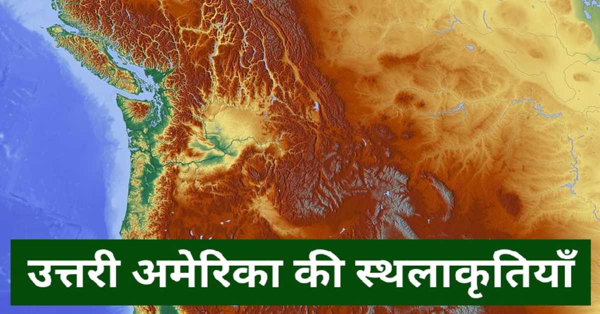


उत्तर अमेरिका महाद्वीप की स्थलाकृतियाँ (भौतिक विशेषताएँ) | Topographies (Physical Features) of the Continent of North America
उत्तर अमेरिका महाद्वीप की स्थलाकृतियाँ (भौतिक विशेषताएँ) में पश्चिमी कॉर्डिलेरा या पर्वत श्रेणी, मध्यवर्ती विशाल मैदान, अपलेसियन पर्वतीय क्षेत्र तथा पूर्वी उच्च भूमि कनाडियन शील्ड का अध्ययन करेंगे।
उत्तर अमेरिका महाद्वीप को भौतिक विशेषताओं के आधार पर चार प्रमुख भागों में वर्गीकृत किया जा सकता है-
1. पश्चिमी कॉर्डिलेरा या पर्वत श्रेणी
2. मध्यवर्ती विशाल मैदान
3. अपलेसियन पर्वतीय क्षेत्र तथा पूर्वी उच्च भूमि
4. कनाडियन शील्ड
The continent of North America can be classified into four major parts on the basis of physical features-
1. Western Cordillera or mountain range
2. Intermediate Great Plains
3. The Appalachian Mountains and the Eastern Highlands
4. Canadian Shield
पश्चिमी कॉर्डिलेरा या पर्वत श्रेणी- उत्तर अमेरिका के पश्चिमी भाग में पश्चिमी कॉर्डिलेरा है। इसे 'प्रशांत कॉर्डिलेरा' के नाम से भी जाना जाता है। इसका विस्तार मेक्सिको प्रदेश से अलास्का तक एक रेखीय रूप में हुआ है। यह मोड़दार पर्वत के रूप में विकसित हुआ है। यह कई समांतर श्रेणियों में वर्गीकृत है। यहाँ की अधिकांश नदियों का उद्गम पश्चिमी कॉर्डिलेरा से ही हुआ है। इन समानांतर श्रेणियों की प्रमुख पर्वत श्रेणियाँ अलास्का श्रेणी, कास्केट श्रेणी, सियरा नेवादा श्रेणी और रॉकी श्रेणी हैं। अलास्का पर्वत श्रेणी की सबसे ऊँची चोटी 'माउंट मैकिन्ले' है। इसकी ऊँचाई 6,194 मीटर है। इसका नया नाम देनाली है। यह पश्चिमी कॉर्डिलेरा के साथ-साथ यूएसए की भी सबसे ऊँची चोटी है। कास्केट श्रेणी की सबसे ऊँची चोटी 'माउंट रेनियर' है। इसकी ऊँचाई 4,392 मीटर है। कोस्ट रेंज की सर्वोच्च चोटी 'माउंट लोगन' है। इसकी ऊँचाई 6,050 मीटर है। यह कनाडा की सबसे ऊँची चोटी है। रॉकी पर्वत श्रेणी की सर्वोच्च चोटी 'माउंट एल्बर्ट' है। इसकी ऊँचाई 4,399 मीटर है। पश्चिमी कॉर्डिलेरा की इन समांतर श्रेणियों के बीच अनेक अंतरापर्वतीय पठार अवस्थित हैं। इनमें से प्रमुख पठार ब्रिटिश कोलंबिया पठार, यूकॉन का पठार, कोलोरैडो और मेक्सिको का पठार, ग्रेट बेसिन हैं। उत्तर अमेरिका महाद्वीप का सबसे बड़ा अंतरापर्वतीय पठार ग्रेट बेसिन है। इस पठार की नदियाँ समुद्र तक नहीं पहुँच पाती। ये अंतःस्थलीय रूप से ही प्रवाहित होती हैं। उत्तर अमेरिका महाद्वीप का सबसे निम्न बिंदु 'मृत घाटी' है। यह विश्व का सबसे गर्म स्थान है। यह ग्रेट बेसिन में ही स्थित है। मृत घाटी यूएसए के कैलिफोर्निया राज्य में स्थित है। यह नेवादा राज्य के 'लॉस वेगास' शहर के निकट है। ग्रेट बेसिन के दक्षिण में कोलोरैडो का पठार स्थित है। यहाँ पर 'ग्रैंट कैनियन' अवस्थित है। यह विश्व का सबसे बड़ा कैनियन है। पश्चिमी कॉर्डिलेरा में गर्म जल के अनेक स्रोत प्राप्त होते हैं। इन्हें 'गीज़र' कहा जाता है। 'ओल्ड-फेथफुल' गीज़र येलोस्टोन पार्क में अवस्थित है। पश्चिमी कॉर्डिलेरा में प्राकृतिक वनस्पतियों की विविधता में स्प्रूस, सेडर और फर के वन पाए जाते हैं। महाद्वीप के पश्चिमी तट पर चिहुआहुआन मरुस्थल स्थित है। यह गर्म मरुस्थल है। इसका विस्तार यूएसए और मेक्सिको में है। यह यूएसए का सबसे बड़ा मरुस्थल है। इसके अतिरिक्त पश्चिमी तट पर ही सोनोरान मरुस्थल अवस्थित है। इसका विस्तार भी यूएसए और मेक्सिको में है। यूएसए के कैलिफोर्निया में 'मोजावे मरुस्थल' अवस्थित है। यह उत्तर अमेरिका का सबसे गर्म मरुस्थल है।
उत्तरी अमेरिका महाद्वीप से संबंधित इन 👇इन प्रकरणों को भी पढ़ें।
1. उत्तर अमेरिका महाद्वीप - सामान्य परिचय
Western Cordillera or Mountain Range— The Western Cordillera is in the western part of North America. It is also known as 'Pacific Cordillera'. It has expanded in a linear form from the territory of Mexico to Alaska. It has developed into a folded mountain. It is classified into several parallel categories. Most of the rivers here have their origin from the Western Cordillera. The major mountain ranges of these parallel ranges are the Alaska Range, the Casket Range, the Sierra Nevada Range, and the Rocky Range. 'Mount McKinley' is the highest peak in the Alaska mountain range. Its height is 6,194 meters. Its new name is Denali. It is the highest peak in the Western Cordillera as well as the USA. The highest peak in the Casket range is 'Mount Rainier'. Its height is 4,392 meters. The highest peak of the Coast Range is 'Mount Logan'. Its height is 6,050 meters. It is the highest peak in Canada. 'Mount Albert' is the highest peak of the Rocky Mountains range. Its altitude is 4,399 meters. Several intermountain plateaus lie between these parallel ranges of the Western Cordillera. The major plateaus of these are the British Columbia Plateau, the Yukon Plateau, the Colorado and Mexico Plateau, the Great Basin. The largest intermountain plateau of the continent of North America is Great Basin. The rivers of this plateau do not reach the sea. They flow inland only. The lowest point on the continent of North America is 'Dead Valley'. It is the hottest place in the world. It is located in the Great Basin itself. Dead Valley is located in the state of California, USA. It is adjacent to the city of 'Las Vegas' in the state of Nevada. To the south of the Great Basin lies the Colorado Plateau. Here is located 'Grant Canyon'. It is the largest canyon in the world. Many sources of hot water are found in the Western Cordillera. These are called 'geysers'. The 'Old-Faithful' geyser is located in Yellowstone Park. The Western Cordillera has a diversity of natural vegetation including spruce, cedar and fir forests. On the west coast of the continent lies the Chihuahuan Desert. This is a hot desert. Its expansion is in the USA and Mexico. It is the largest desert in the USA. Apart from this, Sonoran Desert is located on the west coast itself. Its expansion is also in the USA and Mexico. 'Mojave Desert' is located in California, USA. It is the hottest desert in North America.
अफ्रीका महाद्वीप से संबंधित इन 👇इन प्रकरणों को भी पढ़ें।
1. अफ्रीका महाद्वीप की सामान्य जानकारी
2. अफ्रीका महाद्वीप की पर्वत एवं पठार
3. अफ्रीका महाद्वीप के प्रमुख देश
4. अफ्रीका महाद्वीप के देश एवं उनकी राजधानियाँ
5. अफ्रीका महाद्वीप से संलग्न सागर, महासागर एवं खाड़ियाँ
6. अफ्रीका महाद्वीप की प्रमुख झीलें
7. अफ्रीका महाद्वीप के प्रमुख मरुस्थल
8. अफ्रीका महाद्वीप- नैरोबी, बाब-अल-मंदेब जलसंधि, डरबन, फ़ूटा जालौन पठार, कोको त्रिभुज, साहेल क्षेत्र
मध्यवर्ती विशाल मैदान- यह रॉकी पर्वत के पूर्व और अप्लेशियन पर्वत के पश्चिम में अवस्थित है। इस मैदान का निर्माण नदियों के निक्षेप से हुआ है। यह एक विशाल मैदान है। इसका विस्तार उत्तर अमेरिका के दक्षिण में मेक्सिको की खाड़ी से लेकर उत्तर में मैकेंज़ी नदी के डेल्टाई प्रदेश तक हुआ है। इस मैदान की प्रमुख नदी मिसीसिपी है। इसकी सहायक नदी मिसौरी है। मिसिसिपी नदी का उद्गम 'इटास्का झील' से हुआ है। यहाँ शीतोष्ण घास की अधिकता है। इसलिए इस क्षेत्र को 'प्रेअरी मैदान' के नाम से भी जाना जाता है। यहाँ की मृदा बहुत उपजाऊ है। इस कारण यहाँ कपास, गेहूँ और मक्के की खेती होती है। यूएसए विश्व में मक्के के उत्पादन में अग्रणी देश है। इस मध्यवर्ती विशाल मैदान में 'मक्का की पेटी' स्थित है। यह यूएसए में 'पवन ऊर्जा' उत्पादन का महत्वपूर्ण क्षेत्र है।
Intermediate Great Plains- It is located east of the Rocky Mountains and west of the Appalachian Mountains. This plain is formed by the deposits of rivers. It is a huge field. It has extended from the Gulf of Mexico in the south of North America to the deltaic region of the Mackenzie River in the north. The main river of this plain is Mississippi. Its tributary is Missouri. The Mississippi River originates from 'Itasca Lake'. Temperate grass is abundant here. Hence this area is also known as 'Prairie Plain'. The soil here is very fertile. Because of this cotton, wheat and maize are cultivated here. USA is the leading country in the production of maize in the world. 'Maize Belt' is located in this intermediate large plain. It is an important area of 'wind power' production in USA.
एशिया महाद्वीप से संबंधित इन 👇 प्रकरणों के बारे में भी जानें।
1. एशिया महाद्वीप का विस्तार एवं संबंधित महत्वपूर्ण तथ्य
2. एशिया महाद्वीप की प्रमुख जल संधियां
3. एशिया महाद्वीप की प्रमुख नदियाँ
4. एशिया महाद्वीप के प्रमुख मरुस्थल एवं मैदान
5. एशिया महाद्वीप की प्रमुख झीलें
6. एशिया महाद्वीप की जलवायु, वनस्पति, प्राकृतिक संसाधन तथा कृषि
7. एशिया महाद्वीप के प्रमुख देश
अप्लेशियन पर्वतीय क्षेत्र- यह उत्तर अमेरिका के दक्षिण-पूर्वी क्षेत्र में अवस्थित है। यह अवशिष्ट और मोड़दार पर्वत है। यह अनेक नदियों और हिमानियों का अपरदित क्षेत्र है। यह जल विद्युत ऊर्जा के उत्पादन की दृष्टि से महत्वपूर्ण क्षेत्र है। इस पर्वत से नदियाँ 'प्रपात रेखा' या 'फॉल लाइन' के रूप में गिरती हैं। इस पर्वतीय क्षेत्र की प्रमुख नदी हडसन है। इसके तट पर न्यूयॉर्क शहर स्थित है। अपलेसियन पर्वत की सबसे ऊँची चोटी 'माउंट मिशेल' है। इसकी ऊँचाई 2,037 मीटर है। अप्लेशियन के प्रमुख भाग वाइट हिल्स, ग्रीन माउंटेंस, ब्लैक माउंटेंस और अलेघनी पर्वत हैं। ये संयुक्त राज्य अमेरिका के पूर्वी क्षेत्र में अवस्थित हैं। अपलेसियन पर्वत के पूर्वी किनारे पर 'पीडमोंट का पठार' अवस्थित है। यह पर्वतपदीय पठार है।
Appalachian Mountains- It is located in the southeastern region of North America. It is a residual and twisted mountain. It is an eroded area of many rivers and glaciers. It is an important area for the production of hydroelectric power. Rivers fall from this mountain as 'fall line' or 'fall line'. The main river of this mountainous region is Hudson. On its banks is located New York City. 'Mount Michel' is the highest peak of the Appalachian Mountains. Its height is 2,037 meters. The major parts of the Appalachians are the White Hills, Green Mountains, Black Mountains and Allegheny Mountains. They are located in the eastern region of the United States of America. On the eastern edge of the Appalachian Mountains lies the 'Piedmont Plateau'. This is a mountainous plateau.
भौगोलिक जानकारी से संबंधित इन 👇 प्रकरणों के बारे में भी जानें।
1. भारत में खनिज उत्पादक राज्य
2. भारत में खनिज उत्पाद
3. भारत में परिवहन
4. भारत के प्रमुख औद्योगिक क्षेत्र
5. भारत के उद्योग- स्वतंत्रता प्राप्ति से पहले व बाद में
6. भारत में रसायन उद्योग
7. भारत में प्रमुख लौह इस्पात उद्योग
8. भारत में वस्त्र उद्योग
9. भारत में टेक्नोलॉजी आधारित उद्योग
कनाडियन शील्ड- यह उत्तर अमेरिका महाद्वीप का सबसे प्राचीन भूखंड है। इसका निर्माण कठोर चट्टानों से हुआ है। इस क्षेत्र में अनेक दलदली भूमि और झीलें हैं। इनमें से प्रमुख झीलें हैं- ग्रेट स्लैव, ग्रेट बीयर, अथाबास्का, विनीपेग और रेंडियर हैं। कनाडियन शील्ड के दक्षिण में मीठे पानी की झीलें हैं। ये प्रमुख पाँच झीलें मिशिगन, सुपीरियर, ह्यूरॉन, ईरी और ओंटेरियो हैं। क्षेत्रफल के आधार पर सुपीरियर झील संसार की सबसे बड़ी मीठे पानी की झील है। ओंटारियो और ईरी के मध्य विश्व प्रसिद्ध नियाग्रा जलप्रपात मिलता है। इस शील्ड की प्रमुख नदी सेंट लॉरेंस है। यह ओंटेरियो झील से निकलकर उत्तरी अटलांटिक महासागर में गिरती है। यह महाद्वीप का व्यस्त अंतःस्थलीय जलमार्ग है। इसके अतिरिक्त कनाडियन शील्ड में मैकेंज़ी नदी का प्रवाह होता है। यह कनाडा की सबसे लंबी नदी है। इस शील्ड में पर्याप्त मात्रा में खनिज संसाधन उपलब्ध है। यहाँ पर उपलब्ध प्रमुख खनिज सोना, निकेल, प्लेटिनम, चांदी, कोबाल्ट, यूरेनियम और तांबा हैं। इसी खनिज भंडार के कारण महाद्वीप के सडबरी और ओंटेरियो जैसे शहरों में अनेक उद्योगों का विकास हुआ है।
Canadian Shield- This is the oldest landmass on the continent of North America. It is made of hard rocks. There are many marshy lands and lakes in this area. The major lakes of these are– Great Slav, Great Bear, Athabasca, Winnipeg and Reindeer. To the south of the Canadian Shield are freshwater lakes. These major five lakes are Michigan, Superior, Huron, Erie, and Ontario. By area, Lake Superior is the largest freshwater lake in the world. The world famous Niagara Falls is found between Ontario and Erie. The main river of this shield is Saint Lawrence. It originates from Lake Ontario and falls into the North Atlantic Ocean. It is the busy inland waterway of the continent. Additionally, the Mackenzie River flows into the Canadian Shield. It is the longest river in Canada. Ample mineral resources are available in this shield. The major minerals available here are gold, nickel, platinum, silver, cobalt, uranium and copper. Due to this mineral deposit, many industries have developed in the continent's cities like Sudbury and Ontario.
भारतीय धरातल से संबंधित इन 👇 प्रकरणों के बारे में भी जानें।
1. भारत का आकार विस्तार एवं नामकरण- सामान्य जानकारी
2. हिमालय भारतीय भू आकृतिक संरचना
3. उत्तर भारत का विशाल मैदान
4. भारतीय मरुस्थल
5. भारतीय प्रायद्वीपीय पठार
6. भारत के तटीय मैदान
7. भारत के द्वीप समूह
आशा है, उपरोक्त जानकारी परीक्षार्थियों के लिए ज्ञानवर्धक एवं परीक्षापयोगी होगा।
धन्यवाद।
RF Temre
infosrf.com
संबंधित जानकारी नीचे देखें।
(Watch related information below) 👇🏻

आशा है, उपरोक्त जानकारी उपयोगी एवं महत्वपूर्ण होगी।
(I hope the above information will be useful and important. )
Thank you.
लेखक
(Writer)
infosrf.com
पाठकों की टिप्पणियाॅं (0)
You may also like
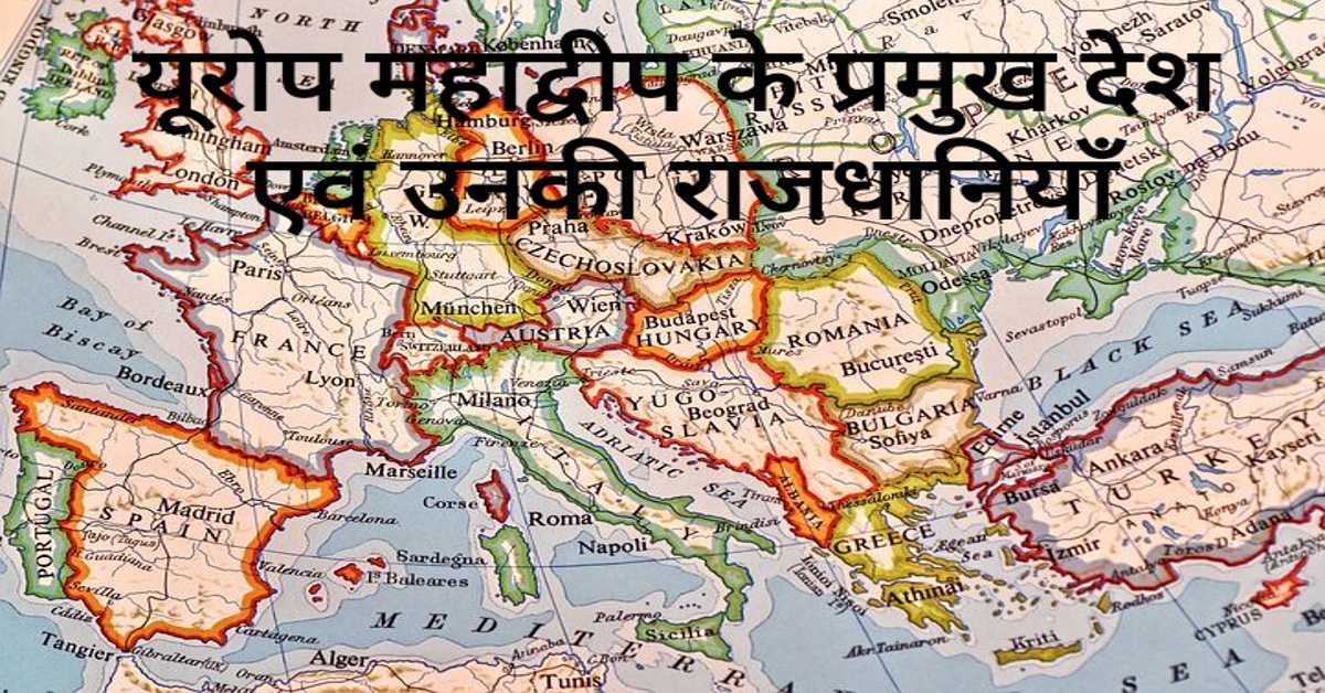
यूरोप महाद्वीप के प्रमुख देश एवं उनकी राजधानियाँ | Europe's Main Countries And Their Capitals
यहाँ यूरोप महाद्वीप के प्रमुख देश एवं उनकी राजधानियाँ दी गई हैं। Europe's Main Countries And Their Capitals given here.
Read more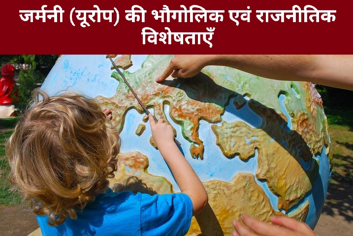
जर्मनी (यूरोप) की भौगोलिक एवं राजनीतिक विशेषताएँ | Geographical And Political Features Of Germany (Europe)
जर्मनी यूरोप महाद्वीप के महत्वपूर्ण देशों में से एक है। इसके उत्तर-पश्चिम में उत्तर सागर स्थित है। जर्मनी के उत्तर-पूर्व में बाल्टिक सागर स्थित है।
Read more.jpg)
फ्रांस (यूरोप) की भौगोलिक एवं राजनीतिक विशेषताएँ | Geographical And Political Features Of France (Europe)
फ्रांस क्षेत्रफल की दृष्टि से यूरोप महाद्वीप का दूसरा सबसे बड़ा देश है। यूरोप महाद्वीप का सबसे बड़ा देश रूस है।
Read more